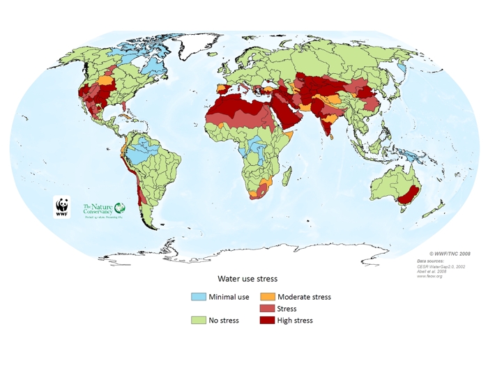
Water stress is defined as the ratio of water use (i.e., surface water withdrawn for domestic, agriculture and livestock use) to water availability (measured as discharge by subbasin, which were delineated at 25,000 sq. kilometers, globally). Water stress, therefore, measures the relative use of water to what is replenished naturally by precipitation and snow melt. Ecosystems and species that are adapted to particular flow patterns in rivers, lakes and wetlands are seriously affected when excessive water is removed from ecosystems. In general, ecoregions where more water is used than gets replenished naturally are considered to be under high water stress, while those with ample supplies are considered to be at low stress. Not surprisingly, arid or populous regions suffer more from water stress, as most of the water resources in those areas have already been heavily tapped. The data used to calculate the water stress indicator is from WaterGAP, a global hydrologic model developed by the University of Kassel in Germany. WaterGap provides both water use and discharges on a global scale. For this analysis, all non-marine areas were divided into consistently-sized subbasins using HydroSHEDS tools. The water stress ration was then calculated for each subbasin and the results upscaled to the ecoregion level. Corrections were made for both very small ecoregions with a high proportion of their area under water stress, and for very large ecoregions with large absolute areas under water stress. Due to data limitations the analysis incorporates only annual values. An analysis of seasonal water stress would likely result in increased stress levels; agricultural water demands, for example, are generally highest in the dry seasons.
Surface water abstraction stress to rivers